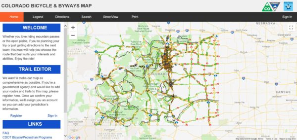
What are the best — and most scenic — roads for bicycling in Colorado? To find out, view the Colorado Bicycle & Byways Map from the Colorado Department of Transportation. This handy interactive map can be used to find bicycle routes all over the state. You can zoom in to find paved and unpaved bike paths as well as locations of roads with on-street bike lanes. The map also provides data on which roads have high volumes of motor vehicles, so that you can find the route with the least traffic. For highways, the amount of truck traffic is also noted. You can also use the map to find routes with extra-wide shoulders; routes where bicycles are prohibited (mainly the busiest highways and interstates); and rest areas, park-and-rides, welcome centers, and ski areas. One of the fun features of the map is that it also traces the routes of Colorado’s Scenic and Historic Byways, many of which include bicycle lanes. So if you’re looking for a scenic route, this is a helpful tool.
The map also includes interactive features that you can use to get directions and to search for locations such as parks or businesses. The map also connects to Street View so that you can virtually see your route before you go.
Whether you’re biking for recreation or to just get from point A to point B, you can find the best and most convenient route with this helpful resource.

- How to Spot the Differences Between Eagles and Hawks - August 16, 2021
- How Transportation Projects Help Tell the Story of Colorado’s Past - August 9, 2021
- Time Machine Tuesday: The Night the Castlewood Canyon Dam Gave Way - August 3, 2021